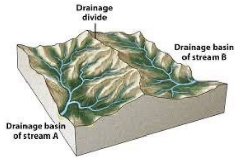
From this point, looking towards Brunswick Basin (it is indeed a basin and used to be very wet in winter before we drained and paved it), can you spot some of our watershed boundaries (hint: ridgelines!)? Now look back towards the college. The hill where the main campus buildings are located is another watershed boundary. Where you are standing, all the water that falls, flows east toward Wolf Creek and on the other side of the hill all the rainwater flows west towards Slate Creek, which flows to Deer Creek, then into the Yuba River. Of course, some of it will flow into the Grass Valley Canal and may become drinking water for the City of Grass Valley, some may be absorbed by soil, trees, shrubs, wildflowers, and grasses on the way to the creeks. Some will end up in storm drains and some will make its way into Matson Creek, which flows hidden along East Main St and flows into Wolf Creek at the roundabout on East Main St.
Desde este lugar, mirando hacia la cuenca hidrológica de Brunswick (de hecho, es una cuenca y solía estar muy húmeda en invierno antes de que fuera drenada y pavimentada). ¿Puedes ver algunos de los límites de la cuenca (una pista: vez las cordilleras)? Ahora mira hacia atrás, dónde está Sierra College. La colina donde se ubican los edificios principales del campus es otro límite divisorio de la cuenca. Donde estás parado, toda el agua que cae, fluye hacia el este al rumbo Wolf Creek. Al otro lado de la colina, toda el agua de lluvia fluye hacia el oeste al rumbo Slate Creek, que fluye hacia Deer Creek, luego hacia el río Yuba. Por supuesto, una parte fluirá hacia el canal de Grass Valley y puede convertirse en agua potable para la ciudad de Grass Valley, otra parte puede ser absorbida por la tierra, los árboles, los arbustos, las flores silvestres y el pasto en el camino hacia los arroyos. Algunas aguas terminarán en los desagües pluviales y otras llegarán a Matson Creek, que pasa oculto a lo largo de East Main Street y desemboca en Wolf Creek donde se ubica la rotonda para coches.